Sunday, February 23, 2020

FROM SANSKARDHANI TO SMART CITY JABALPUR

Today, I am discussing about Sanskardhani of Madhya Pradesh. The city of today has its historical background too. Jabalpur was known as Tripuri during the Hayahaya Rulers. Moreover, the great Mahatma Gandhi's mortal remains were flown in River Narmada.
Before British rule, the sanskardhani was known by the name Jabalipuram. the name was given on the name of sage 'Jabali'. When British Rule came to India they called the city Jaboulpor, as there accent doesn't match to hindi accent.
Jabalpur can also be seen in Mahabharata. The city was very well organised and maintained during that period.
Jabalpur was also ruled by Gupta rulers and Mauryan then Kalchuri took over and Jabalpur had became the capital of Kalchuri dynasty in 875AD. Later in 13th century Gond took it and made their capital. Gond rule was at its peak during 16th century and known as Kingdom of Gondwanas. When Mughal came, Gond queen Rani Durgawati was ruling Jabalpur and she died fighting to the forces under Mughal King Akbar. In 1789 battle , Marathas took this from Mughals. British took this in 1817 and they ruled until freedom of India. Jabalpur was headquarter of Territory of Narmada during British period.  Many of us have heard about famous session of congress, The Tripuri session 1939, during movement of freedom headed by Netaji Subhash Chandra Bose.

Due to cultural richness of Jabalpur, this city is known by the name "SANSKARDHANI".

After Independence of India, the Mahalaushal was redesigned as of present by including Central Province and Brar into Madhya Pradesh. 

There are many places which are true historical mirror of city like Chosath yogini temple in hillock designed by Kalchuri Rulers in 10th century. It has the significant signs of Mughal invasion faced by country. All the monuments and idols were broken during Aurangzeb 
rule.
Madanmahal fort which was built by Gond ruler Madan shah. Rani durgawati fort  which was built by Gond  female ruler Rani Durgawati.
Narmada River shows its beauty by falling from Marble Rocks and making a smoking fall. This site is known as Dhuadhar Jalprapat located in Bhedaghat, Jabalpur. On river Narmada many river banks are made for spiritual purposes like Gwarighat, Tilwaraghat, Lamhetaghat etc. People visit here on the auspicious dates mainly in full moon and no moon days which falls twice in a month.

If you are a Hinduism believer there are many place to visit here like Kachnar city Shiva Temple, Ramayana temple, Bajnamath temple (built by gond ruler Sangram Shah famous for tantrik practices), Gwahighat Hanuman lala temple, gwarighat Siddhivinayak temple, Sharda Temple of Garha region.

There are many ponds here like devtaal, supatal, hathital, ranital etc.


I am Skipping details of political ruling after the Indian freedom and details of defence sectors situated in the Jabalpur.

  The Smart city project was launched in India in 25-JUNE-2015 by newly elected Central Government. The mission was launched  to make 100 city of country more developed. Jabalpur Smart city limited was established on 14th of March 2016 to take care of all the development project across the city.

At the present date,all project are at their running stage or at their verge of start. 

In future there may be a possibility of a good infrastructure like Metro cities.


Thursday, February 25, 2016

THE DRAINAGE SYSTEM OF INDIA


DRAINAGE SYSTEM:
  • The drainage system refers to system of rivers and its tributaries that belongs to the particular area. These rivers flow and divid then again join each other to make a big stream of water and finally drains into a big water body. These large water body may be anything like a big lake or a sea or an ocean. 
  • The area drained by the single river system is called as the Drainage Basin.
  • The separation between two Drainage Basins refers to the Water Divide.
  • The World's largest drainage basin is of the Amazon River.
DRAINAGE SYSTEM OF INDIA: 

Indian Drainage system is divided into two broad groups :

  1. The Himalayan Rivers
  2. The Peninsular Rivers

purchase your bag here and get ultimate discount
DIFFERENCE BETWEEN RIVER SYSTEMS:
BEST INDIAN GEOGRAPHY BOOK
The Himalayan river system and The Peninsular River system are different from each other in many ways :
  • Most of the Himalayan rivers are perennial(Himalayan rivers get water throughout the year.), while a large number of Peninsular rivers are seasonal.
  • Himalayan Rivers have two major water sources, that is, rain and melted snow water from lofty mountains., while Peninsular rivers flow is dependent on rainfall. During the Dry season, the large number of Peninsular rivers also get affected in their flow.
  • The Peninsular Rivers have shorter and shallower courses as compared to their Himalayan counterparts. However some of them originates from the central highlands and flow towards west. These two rivers are Narmada and Tapti.
  • Most of the Rivers of Peninsular India originate in the Western Ghats and flow towards the Bay of Bengal.

1. HIMALAYAN RIVERS:

The Himalayan Rivers are separated in three major river systems:
  1. The Indus river system
  2. The Ganga river system 
  3. The Brahmaputra river system
*RIVER SYSTEM: A river with its tributaries is known as a river system.
GET YOUR GEOGRAPHY BOOK HERE AT GOOD PRICE

  1.THE INDUS RIVER SYSTEM:

  • Near Mansarovar lake, in Tibet, the Indus river originates.
  • Flowing to the west, it enters in Indian from Ladakh district of J&K state. Indus river forms a picturesque gorge in this part.
  • Several  tributaries, the Zaskar, the Nubra, the Shyok and the Hunza, join it in the Kashmir region.
  • The indus flows through Baltistan and Gilgit and emerges from the mountains at Attock. 
  • The satluj, the Beas, the Ravi , the Chenab and the jhelum join together to enter the Indus near Mithankot in Pakistan.
  • Beyond this, the Indus flows southwards eventually reaching the Arabian sea, east of Karachi.
  • The Indus plain has a very gentle slope. with a total length of 2900 km, the Indus is one of the longest rivers of the world.
  • A little over the third of Indus basin is located in India in the state of jammu and Kashmir, Himachal Pradesh and the Punjab and the rest is in Pakistan.
***According to the Regulations of the Indus water Treaty which was done in 1960, India can use only 20 % of total water carried by Indus river system. This water is used for irrigation in the Punjab, Haryana and the southern and western part of Rajasthan.


  2.THE GANGA RIVER SYSTEM:

  • The headwater of the Ganga called the Bhagirathi is fed by the Gangotri glacier and joined by the Alaknanda at Devprayag in Uttarakhand.
  • At Haridwar the ganga emerges from the mountains on to the plains.
  • The Ganga is joined by many tributaries from the Himalayas, a few of them being major rivers such as the Yamuna, the Ghaghara, the Gandak and the Kosi. 
  • The Yamuna river rises from the Yamunotri Glacier in the Himalayas.It flows parallel to the Ganga and as a right Bank Tributary, meets the Ganga at Allahabad.
  • The Ghaghara, the Gandak and the kosi rise in the Nepal Himalaya. They are the rivers, which flood parts of the northern plains every year, causing widespread damage to life and property but enriching the soil for the extensive agricultural lands.
  • The main tributaries, which come from the peninsular uplands, are the Chambal , the Betwa and the Son. These rise from semi arid areas, have shorter courses and do not carry much water in them.


Wednesday, February 24, 2016

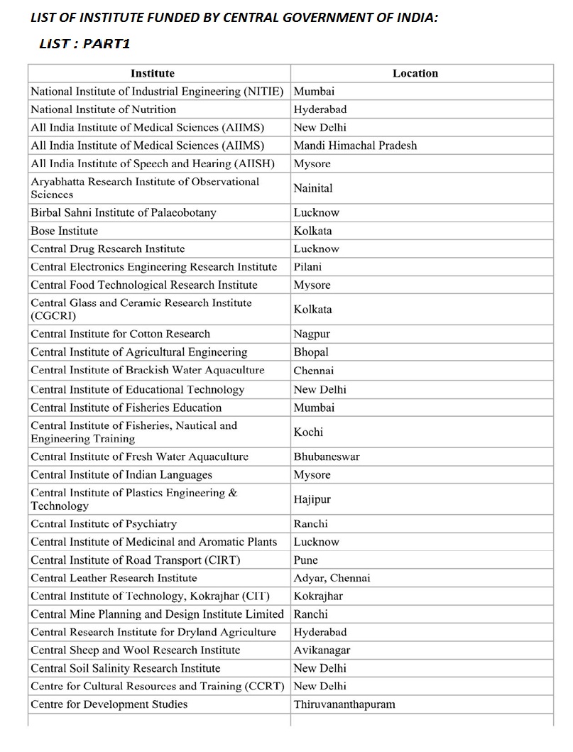
LIST OF INDIAN INSTITUTES FUNDED BY CENTRAL GOVERNMENT OF INDIA

LIST OF INDIAN INSTITUTES:


Here I am adding list of the indian institutes that are funded by Central GoI.
 These lists can be saved in your device by just single click. Please share this page.


Monday, February 15, 2016

LIST OF INDIAN PASSES

IN STATE JAMMU AND KASHMIR:

  1. KARAKORAM PASS *more
  2. ZOJILA PASS *more
  3. PIR PANJAL PASS
  4. BARAMULA PASS
  5. BURZIL PASS
  6. BANIHAL PASS SEE LOCATION
  7. KHUNJERAB PASS 
  8. AGHIL PASS 
  9. YANGI PASS
  10. HAJI LANGAR PASS
  11. JARA LA PASS
  12. CHANGLA PASS(LEH AND CHANGTHANG) 
  13. DEHRA PASS(@LADAKH)
  14. FOTU PASS(@LADAKH)
  15. KHARDUNGLA PASS
  16. KONGKA PASS (LADAKH AND AKSAI CHIN)
  17. LANAK PASS ( LADAKH AND TIBET)
  18. MARSIMIK PASS(@LADAKH)
  19. NAMIKA LA PASS(@LADAKH)
  20. PENSI LA PASS(@LADAKH)
  21. REZANG LA PASS(@LADAKH)
  22. SASSER PASS (@LADAKH)(NUBRA AND SIACHEN GLACIER)
  23. SIA LA PASS(@SIACHEN GLACIER)
  24. SHINGO LA PASS(@LADAKH)
  25. SPANGUR LA PASS (@LADAKH)
  26. GYONG LA PASS(@SIACHEN GLACIER)
  27. BILAFOND LA PASS(@SIACHEN GLACIER)
  28. TANGLANG LA PASS(@LADAKH)

IN HIMACHAL PRADESH:

  1. SHIPKI LA PASS
  2. ROHTANG PASS
  3. BARALACHA PASS
  4. DEBSA PASS
  5. CHANSHAL PASS
  6. INDRAHAR PASS

IN SIKKIM :

  1. NATHULA PASS
  2. JELEPLA PASS
  3. GOECHA LA PASS
  4. SONGKHLA PASS

IN UTTARAKHAND:

  1. THAGA LA PASS 
  2. MANA PASS
  3. NITI PASS
  4. LIPULEKH PASS
  5. SIN LA PASS
  6. TRAILL'S PASS
  7. NAMA PASS (@NANDA DEVI BIOSPHERE RESERVE OF INDIA)
  8. AUDEN'S COL

IN ARUNACHAL PRADESH:

  1. YANG YAP PASS
  2. DIFU PASS
  3. DUMULA PASS
  4. SELA PASS

IN MADHYA PRADESH 

  1. ASIR GARH

IN RAJASTHAN :

  1. HALDIGHATI PASS

IN KERALA:

  1. SENGOTTAI PASS(TRAVANCORE AND TAMIL NADU )
  2. PALAKKAD GAP(KERALA AND TAMIL NADU)

Sunday, February 7, 2016

THE ISLANDS OF INDIAN UNION

THE ISLANDS OF INDIAN UNION:


As we have seen in the other pages of this blog ,India is having a vast geographical land. Besides this the country has the two group of islands :

  1. The Lakshadweep Islands
  2. The Andaman and Nicobar Islands 

1. THE LAKSHADWEEP ISLANDS:(Total number of islands =43)

  • The Lakshadweep Islands group lies near the Malabar coast of Kerala. This group of islands is composed of small coral islands.
  • Earlier they were Known as Laccadive, Minicoy and Amindivi. In 1973 these were named as the Lakshadweeps.
  • It covers small area of 32 sq. km.
  • Kavaratti Island is the administrative headquarters of Lakshadweep.
  • This island group has great diversity of flora and fauna.
  • The Pitti Island, which is uninhabited has a bird sanctuary.


2. THE ANDAMAN AND NICOBAR ISLANDS: (Total number of islands =204)


  • These are the elongated chain of islands located in the Bay of Bengal extending from North to South. These are Andaman and Nicobar islands.
  • They are more numerous and scattered. total number of islands are 204.
  • Total Area is 7950 square km.
  • As of 2012 the population was 380500. 
  • One of the seven union territories of India, are a group of islands at the juncture of the Bay of Bengal and Andaman Sea.
  • The territory is 150 km (93 mi) north of Aceh in Indonesia and separated from Thailand and Myanmar (Burma) by the Andaman Sea.


  • The entire group of islands is divided into two broad categories : ( separated by the 10°N parallel)

  1. The Andaman in the north 
  2. Nicobar in the south. 
  • The territory's capital is the Andamanese town of Port Blair.
  • The capital of Nicobar Islands is Car Nicobar. 
  • The islands host the Andaman and Nicobar Command, the only tri-service geographical command of the Indian Armed Forces.
  • The Andaman Islands are home to the only known Paleolithic people, the Sentinelese people, who have no contact with any other people.

NOTE : 

  • India's only active volcano is founded in the Barren island of the Andaman and nicobar group of islands.
  • Duncan Passage is a strait in the Indian Ocean. It is about 48 km (30 mi) wide; it separates Rutland Island (part of Great Andaman)and Little Andaman. West of Duncan Passage is the Bay of Bengal; east is the Andaman Sea.
  • Several small islands and islets lie along the passage. North to south, they are:
  1. North Cinque Island
  2. South Cinque Island
  3. Passage Island
  4. The Sisters
  5. North Brother Island
  6. South Brother Island

  • Manners Strait is the branch of Duncan Passage that lies between North Cinque Island and Rutland Island.

Flora:

Map of Andaman and Nicobar Islands with an extra detailed area around Port Blair.
  • The Andaman and Nicobar Islands have a tropical rainforest canopy, made of a mixed flora with elements from Indian, Myanmar, Malaysian and endemic floral strains. So far, about 2,200 varieties of plants have been recorded, out of which 200 are endemic and 1,300 do not occur in mainland India.
  • The South Andaman forests have a profuse growth of epiphytic vegetation, mostly ferns and orchids. The Middle Andamans harbours mostly moist deciduous forests. North Andamans is characterized by the wet evergreen type, with plenty of woody climbers. 
  • The North Nicobar Islands (including Car Nicobar and Batti Malv) are marked by the complete absence of evergreen forests, while such forests form the dominant vegetation in the central and southern islands of the Nicobar group. Grasslands occur only in the Nicobars, and while deciduous forests are common in the Andamans, they are almost absent in the Nicobars. The present forest coverage is claimed to be 86.2% of the total land area.
  • This atypical forest coverage is made up of twelve types, namely:

  1. Giant evergreen forest
  2. Andamans tropical evergreen forest
  3. Southern hilltop tropical evergreen forest
  4. Cane brakes
  5. Wet bamboo brakes
  6. Andamans semi-evergreen forest
  7. Andamans moist deciduous forest
  8. Andamans secondary moist deciduous forest
  9. Littoral forest
  10. Mangrove forest
  11. Brackish water mixed forest
  12. Submontane forest

Fauna:

Rose island andaman
  • This tropical rain forest, despite its isolation from adjacent land masses, is surprisingly rich with a diversity of animal life.
  • About 50 varieties of forest mammals are found to occur in the Andaman and Nicobar Islands. 
  • Some are endemic, including the Andaman Wild Boar. Rodents are the largest group with 26 species, followed by 14 species of bat. 
  • Among the larger mammals there are two endemic varieties of wild boar, Sus scrofa andamanensis from Andaman and Sus scrofa nicobaricus  from Nicobar, which are protected by the Wildlife Protection Act 1972 (Sch I).
  • Saltwater crocodile is also found in abundance. The State animal of andaman is the dugong, also known as the sea cow, which can be found in Little Andaman. Around 1962 there was an attempt to introduce the leopard, which was unsuccessful because of unsuitable habitat. These were ill-considered moves as exotic introductions can cause havoc to island flora and fauna.
  • About 270 species of birds are found in the territory; 14 of them are endemic, the majority to the Nicobar island group. The islands' many caves are nesting grounds for the Edible-nest Swiftlets, whose nests are prized in China for bird's nest soup.
  • The territory is home to about 225 species of butterflies and moths, including some of the larger and most spectacular of the world. Ten species are endemic to these Islands. Mount Harriet National Park is one of the richest areas of butterfly and moth diversity on these Islands.
  • The islands are well known for prized shellfish, especially from the genera Turbo, Trochus, Murex and Nautilus. Earliest recorded commercial exploitation began during 1929. Many cottage industries produce a range of decorative shell items. Giant clams, green mussels and oysters support edible shellfishery. The shells of scallops,clams, and cockle are burnt in kilns to produce edible lime.

There are 96 wildlife sanctuaries, 9 National Parks and 1 Biosphere Reserve in these islands. 


Saturday, February 6, 2016

THE INDIAN COASTAL PLAINS


THE COASTAL PLAINS OF INDIA:

The Peninsular plateau is flanked by stretch of narrow coastal strips, running along the Arabian sea on the west and the Bay of Bengal on the east. There are two coast can be seen across the western and eastern regions of India:

1.THE WESTERN COAST OF INDIA:

  • The Western Coastal Plains is a thin strip of coastal plain 50 kilometres (31 mi) in width between the west coast of India and the Western Ghats hills, which starts near the south of river Tapi.
  • The Western Coast, sandwiched between Western Ghats and the Arabian Sea, is a narrow plain. 
  • The plains begin at Gujarat in the north and end at Kerala in the south. It also includes the states of Maharashtra, Goa and Karnataka.
  • It consists of three sections: 
  1. The northern part of the coast is called the Konkan(Mumbai-Goa),
  2. The central stretch is called the Kannad Plain 
  3. The southern stretch is referred to as the Malabar Coast.

  • On its northern side there are two gulfs: the Gulf of Khambhat and the Gulf of Kachchh.The rivers here end up forming estuaries and therefore it is ideal for pisciculture.

2.THE EASTERN COAST OF INDIA:

  • The plain along the Bay of Bengal are wide and level.
  • In the Northern part,it is referred to northern Circar between Mahanadi and Krishna rivers and Coromandel Coast in the southern part between Krishna and Kaveri rivers. 
  • The Southern part is known as the Coromandel Coast. Large rivers such as the Mahanadi, the Godavari, the Krishna and the Kaveri have formed extensive Delta on this coast. 
  • Lake Chilka is an important feature along the Eastern Coast.
  • The Chilka lake is the largest saltwater lake in India. It lies in the state of Orissa, to the south of The Mahanadi River.
  • The region receives both the Northeast & Southwest monsoon rains with its annual rainfall averaging between 1,000 mm CIRCAR(40 in) and 3,000 mm (120 in). The width of the plains varies between 100 to 130 km (62 to 80 miles).

Friday, February 5, 2016

FORTHCOMING POSTS

  • INDIAN DRAINAGE SYSTEM
  • ARCHEOLOGICAL SITES OF INDIA
  • VARIOUS INDIAN MANUSCRIPTS FOUND IN EXCAVATION
  • TEMPLES OF INDIA
  • IMPORTANT HISTORICAL SITES 
  • INDIAN RAILWAYS AND ITS EXPANSION
  • ETC...TOPICS ARE BEING CONSIDERED FOR POST.....

LIST OF INDOOR ARENA OF INDIA


RIGHT CLICK ON THE IMAGES AND SAVE THEM FOR READING 

 GO THROUGH OTHER PAGES 

IF YOU REALLY LIKE THIS PAGE PLEASE DO SHARE WITH YOUR FRIENDS 

LIST OF CRICKET STADIUM OF INDIA


INDIAN AIRPORTS BY TRAFFIC RANKING


Thursday, February 4, 2016

THE GREAT INDIAN DESERT

THE GREAT INDIAN DESERT AND ITS EXTENSION


  • The Thar Desert, also known as the Great Indian Desert, is a large, arid region in the northwestern part of the Indian subcontinent that forms a natural boundary between India and Pakistan.  
  • It is the world's 17th largest desert, and the world's 9th largest subtropical desert.
  •  About 85% of the Thar Desert is in India, and the remaining part in Pakistan. 
  • In India, it covers about 320,000 km2 (120,000 sq mi), of which 60% is in Rajasthan and extends into Gujarat, Punjab, and Haryana. 


  • This desert comprises a very dry part, the Marusthali region in the west, and a semi desert region in the east with fewer sand dunes and slightly more precipitation.
  • The indian desert lies towards the western margins of the Aravali Hills.
  •  Its is an undulating sandy plain covered with sand dunes.
  •  This region receives very low rainfall below 150mm per year. It has arid climate with low vegetation cover. Streams appear during the rainy season. Soon after they disappear into the sand as they do not have enough water to reach the sea. 


  • Luni is the only large river in this region.


  • Barchans ( crescent shaped dunes) cover larger area but longitudinal dunes become more prominent near the Indo- Pakistan boundary. If you visit Jaisalmer , you may go to sea a group of barchans. 

THE PENINSULAR PLATEAU

  PROPERTIES OF PENINSULAR PLATEAU: 

  • The Peninsular Plateau is a tableland composed of the old crystalline, igneous and metamorphic rocks.
  • It was formed due to the breaking and drifting of Gondwanaland and thus making it a part of the oldest landmass.
  • The plateau has broad and shallow valleys and rounded hills.


DIVISIONS OF PENINSULAR PLATEAU:

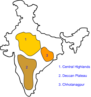
The Peninsular plateau can be divided into two major parts :

  1. Central Highlands 
  2. Deccan Plateau


1.CENTRAL HIGHLANDS:


  •  The part of the Peninsular Plateau lying to the North of Narmada river covering a major area of the Malwa Plateau is known as Central Highlands. 
  • Vindhya range is bounded by the central highlands on the South and the Arawali Ranges on the Northwest.
  • The further westward extension gradually merges with the sandy and rocky desert of Rajasthan.The flow of the rivers draining this region, namely the Chambal, the Sind , the Betwa and Ken is from Southwest to the Northeast, thus indicating the slope.
  • The Central Highlands are wider in the west but narrower in the east. The eastward extension of this plateau are locally know as the Bundelkhand and Baghelkhand.
  • The Chhotanagpur plateau marks the further eastward extension, drained by the Damodar river.

2.DECCAN PLATEAUS:


  • The Deccan Plateau is a triangular landmass that lies to the south of the river Narmada.
  • The Satpura Range flanks its broad base in the north while the Mahadev, the Kaimur hills ans the Maikai Range form its eastern extensions.
  •  Locate these hills and ranges in the physical map of india. The deccan plateau is the higher in the west and slopes gently eastwards. An extension of the plateau is also visible in the northeast locally known as the Meghalaya, Karbi-Anglong Plateau and North cachar Hills. 
  • It is separated by  a fault from the Chhotanagpur plateau. 
  • Three prominent hill ranges from the west to east are the Garo, the Khasi and the Jaintia Hills. 
  • The western and the eastern ghats mark the western and the eastern edges of the deccan plateau respectively.
  • Western ghats lie parallel to the western coast.They are continuous and can be crossed through passes only.
  • Locate the Thal, Bhor and Pal Ghats in the Physical map of India.
  • The Western Ghats are higher than the Eastern Ghats. Their average elevation is 900-1600 meters as against 600 meters of the eastern Ghats.
  • The eastern ghats stretch from the Mahanadi Valley to the Nigiris in the south. 
  • The Eastern Ghats are discontinuous and irregular and dissected by rivers draining into the bay of bengal.
  •  The Western Ghats cause orographic rain by facing the rain bearing moist winds to rise along the slopes of the Ghats.
  •  The western ghats are known by different local names. 
  • The highest peaks include the Anai Mudi(2,695 meters)and Doda Betta (2,637 meters).
  •  Mahendragiri(1,501 meters) is the highest peak in the eastern ghats.
  •  Shevroy Hills and the Javadi hills are located to the southeast of the eastern ghats. Locate the famous hill stations of Udhagamandalam, popularly known as Ooty and the Kodaikanal.
  • One of the distinct features of the Peninsular plateau is the black soil area known as Deccan Trap. This is the volcanic origin hence the rocks have denuded over the time and are responsible for the formation of the black soil. The aravali hills lie on the western and northwestern margins of the peninsular plateau. These are highly eroded hills and are found as broken hills. They extend from Gujarat to Delhi in a southwest - northeast direction.